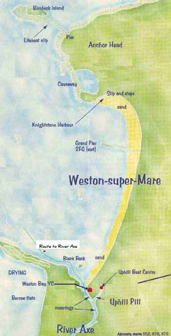
Weston Bay is bounded by Brean Down and Howe Rock to the South and Birnbeck Island and Honeycomb Rock to the North although the latter rock is never seen.
A common approach is along a transit between Steep Holm island and the Grand Pier to find the Churchill Buoy. If this buoy is difficult to spot, for reasons including it not being there, then the intersection of this position line with the 5 metre contour line is a good place to start from. This keeps you well North of Brean Down, away from an area that can get choppy.
If your purpose is to wait for the next tide there are two anchorages but neither is safe or comfortable in foul weather. To the North is The Gut near the lifeboat slipway – to the South an area near Brean Down but stay clear of the old fort. See the Uphill Local Pilot.
If you wish to visit Weston, you can use Knightstone Harbour, though access is limited by the tide height and heavy swells can be a problem. (This was once the home of WBYC.)
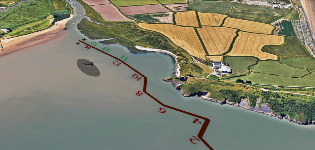
The River Axe can be entered around 1 and three quarter hours either side of high water. The nearer you are to half-tide, the more care is needed to find the channel and avoid the mud flats. The channel is natural, not dredged, and so it will move over time. You can get a good impression by looking-up the river entrance on Google Earth.
(The channel is quite narrow, with a significant dog-leg to negotiate – you should have a functional depth sounder on board.)
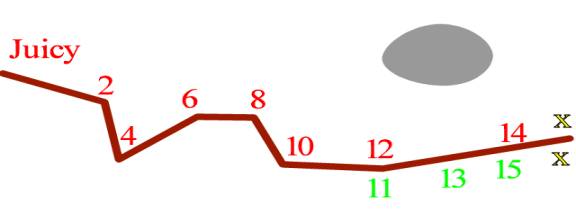
The outer mark to the channel is the Juicy Buoy, a Red / White safe water buoy, with light.

This bouy is placed at the edge of the mud bank, so unless there is plenty of water, get to the bouy first, and then look for the channel.
From Juicy, steer towards Black Rock. You should be able to pick out the first of the port-hand marks which guide you around the dog-leg. All the initial marks, until well into the river, are port-hand marks. Some of these marks are lit.
Stay reasonably close to the initial port-hand marks, and avoid cutting corners. The river itself is marked by port and starboard hand bouys. You’ll find deeper water between the marks.
Having reached the river, if you are looking to use the Pill to get to the boatyard or the wharf, then do not cut the corner. There is a significant mud bank. Choose a path through the ‘channel’ defined by the boat moorings. Further up the Pill, you may spot some marker bouys. Go carefully, and keep an eye on your depth sounder.
If you have no experience of the Pill, avoid it at high spring tides. The river floods the lower banks, and you will not be able to make out the channel.
Do not attempt to cut the corner.
The channel curves to starboard towards these buoys which should be rounded close to port.
Disclaimer: Whilst every effort has been made to make this information accurate, it is the skipper in charge who has the responsibility to ensure safe navigation of the river. WBYC will accept no responsibility for any mishap from using this information.